Example 12: Lunar Navigation Constellation Design
This tutorial designs a lunar navigation constellation for south-pole service. Unlike the previous examples, which estimate the state of one vehicle, this notebook studies the geometry of many relay satellites and many users over time.
We build a reusable LunarNavConstellation class that can generate a symmetric ELFO Walker-type constellation, propagate it, compute visibility and dilution of precision, estimate required EIRP, and optimize satellite phasing.
The central design metric is PDOP. If the line-of-sight unit vectors to visible satellites form the geometry matrix \(G\), then the covariance-like DOP matrix is
Low PDOP means the visible satellites surround the user with strong geometry; high PDOP means the same range noise produces a larger position error. The tutorial optimizes phasing to maximize the fraction of south-pole user-time samples with PDOP < 6.
0. Imports and constants
[1]:
import numpy as np
import matplotlib.pyplot as plt
from matplotlib import cm
import plotly.graph_objects as go
from scipy.optimize import brentq, differential_evolution

import pylupnt as pnt

np.set_printoptions(precision=4, suppress=True)

# --- Physical constants (SI: metres, seconds, radians) -----------------------
GM_MOON = pnt.GM_MOON  # [m^3/s^2] Moon gravitational parameter
R_MOON = pnt.R_MOON  # [m]       Moon mean radius
OMEGA_EM = (
    pnt.OMEGA_EARTH_MOON
)  # [rad/s]  Earth-Moon mean motion (= Moon spin, tidally locked)
T_SIDEREAL_MONTH = 2 * np.pi / OMEGA_EM  # [s]
J2_MOON = 2.0330e-4  # [-] Moon oblateness (unnormalized C20 magnitude)

RAD, DEG = pnt.RAD, pnt.DEG  # deg->rad and rad->deg multipliers
SECS_HOUR, SECS_DAY = pnt.SECS_HOUR, pnt.SECS_DAY

print(f"GM_MOON          = {GM_MOON:.5e} m^3/s^2")
print(f"R_MOON           = {R_MOON/1e3:.1f} km")
print(f"Sidereal month   = {T_SIDEREAL_MONTH/SECS_DAY:.4f} days")

# Host heavy interactive figures on lupnt-doc-assets instead of embedding them.
import sys as _sys
from pathlib import Path as _Path

for _p in [_Path.cwd(), *_Path.cwd().parents]:
    if (_p / "python" / "examples" / "_doc_assets.py").exists():
        _sys.path.insert(0, str(_p / "python" / "examples"))
        break
from _doc_assets import embed_plotly, embed_cesium_scene
[00.00][PyLuPNT] Initializing
GM_MOON          = 4.90280e+12 m^3/s^2
R_MOON           = 1737.4 km
Sidereal month   = 27.3217 days
1. Orbit design: resonant semi-major axis and frozen \((e,i)\)
Resonant semi-major axis. We pick the orbital period so that an integer number of revolutions \(N_\text{rev}\) fit exactly in one sidereal month. This makes the ground track (and the whole constellation geometry relative to both the rotating Moon and the Earth direction) repeat every month, which is exactly the window over which we assess availability.
For a target of \(\approx 30\) h we take \(N_\text{rev}=22\) (\(T\approx 29.8\) h).
Frozen inclination. With the argument of perigee fixed at the frozen value \(\omega=90^\circ\), the secular rate of \(\omega\) from the Moon’s \(J_2\) plus the doubly-averaged Earth third-body (quadrupole/Kozai) perturbation must vanish. Since \(\dot e = 0\) automatically at \(\omega=90^\circ\), the condition \(\dot\omega = 0\) closes the frozen orbit and fixes the inclination for a given \((a,e)\):
with \(p=a(1-e^2)\), \(n=\sqrt{GM/a^3}\) and \(n_E=\Omega_\text{E-M}\). We solve \(\dot\omega_{J_2}+\dot\omega_{3B}=0\) for \(i\).
[2]:
def resonant_sma(n_rev, gm=GM_MOON, t_repeat=T_SIDEREAL_MONTH):
    """Semi-major axis [m] and period [s] for n_rev revolutions per repeat window."""
    period = t_repeat / n_rev
    a = (gm * (period / (2 * np.pi)) ** 2) ** (1.0 / 3.0)
    return a, period


def omega_dot(a, e, inc, gm=GM_MOON, n_third=OMEGA_EM, j2=J2_MOON, r_body=R_MOON):
    """Secular apsidal rate [rad/s] at omega=90deg: Moon-J2 + Earth third-body (quadrupole)."""
    n = np.sqrt(gm / a**3)
    p = a * (1.0 - e**2)
    w_j2 = 0.75 * n * j2 * (r_body / p) ** 2 * (5 * np.cos(inc) ** 2 - 1.0)
    w_3b = (
        0.75
        * (n_third**2 / n)
        / np.sqrt(1 - e**2)
        * (2 + 3 * e**2 - 5 * np.sin(inc) ** 2)
    )
    return w_j2 + w_3b


def frozen_inclination(a, e, **kw):
    """Solve omega_dot(a, e, i) = 0 for the frozen inclination i in (0, 90) deg."""
    f = lambda inc: omega_dot(a, e, inc, **kw)
    return brentq(f, 5 * RAD, 89 * RAD)


# --- Design the reference ELFO -------------------------------------------------
N_REV = 22  # revolutions per sidereal month  (resonance)
ECC = 0.60  # design eccentricity
a_ref, period_ref = resonant_sma(N_REV)
inc_ref = frozen_inclination(a_ref, ECC)
argp_ref = 90.0 * RAD

print(f"Resonance          : {N_REV} rev / sidereal month")
print(f"Orbital period     : {period_ref/SECS_HOUR:.3f} h")
print(f"Semi-major axis    : {a_ref/1e3:.2f} km")
print(f"Eccentricity       : {ECC:.3f}")
print(f"Frozen inclination : {inc_ref*DEG:.3f} deg   (omega = 90 deg)")
print(f"Perilune altitude  : {(a_ref*(1-ECC)-R_MOON)/1e3:.0f} km")
print(f"Apolune  altitude  : {(a_ref*(1+ECC)-R_MOON)/1e3:.0f} km")
Resonance          : 22 rev / sidereal month
Orbital period     : 29.805 h
Semi-major axis    : 11265.75 km
Eccentricity       : 0.600
Frozen inclination : 51.757 deg   (omega = 90 deg)
Perilune altitude  : 2769 km
Apolune  altitude  : 16288 km
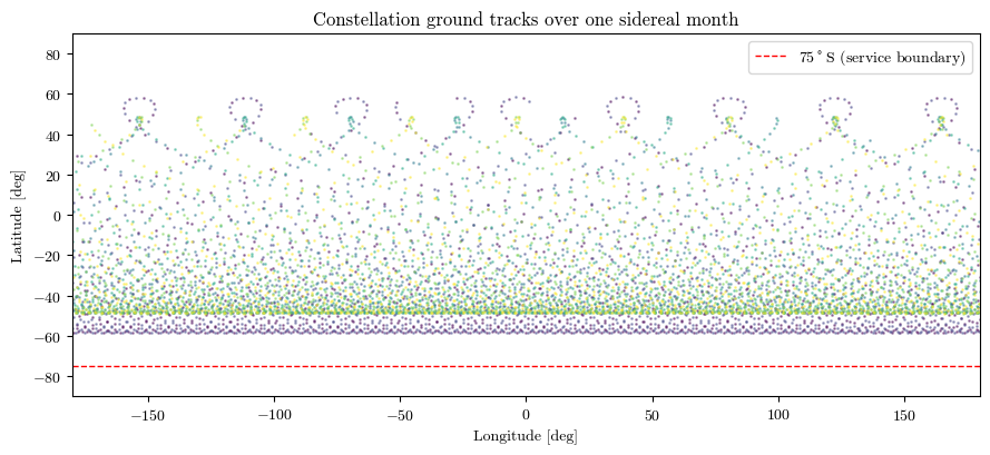
The frozen inclination comes out near \(52^\circ\). With \(\omega = 90^\circ\) the perilune sits over the northern hemisphere and the satellite dwells near apolune over the southern hemisphere at an altitude of \(\sim16{,}000\) km — ideal for continuous South-Pole visibility.
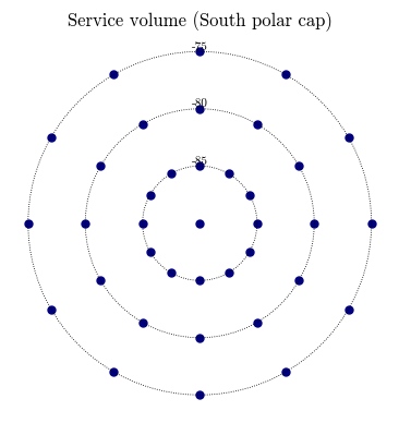
3. The service volume (South-Pole users)
The service volume is the region we must serve. We take the South-Pole cap: all surface locations with latitude below 75°S, sampled on a latitude×longitude grid. (Altitude is set to the surface; the class accepts any altitude, so aerial/orbital users can be added the same way.)
[4]:
def south_polar_users(lat_max_deg=-75.0, dlat_deg=5.0, dlon_deg=30.0, alt_m=0.0):
    """Grid of [lat, lon, alt] (rad, rad, m) over the cap lat <= lat_max_deg."""
    lats = np.arange(-90.0, lat_max_deg + 1e-9, dlat_deg)
    lons = np.arange(0.0, 360.0, dlon_deg)
    users = [[-90.0 * RAD, 0.0, alt_m]]  # the pole itself (once)
    for la in lats:
        if la <= -89.99:
            continue
        for lo in lons:
            users.append([la * RAD, lo * RAD, alt_m])
    return np.array(users)


SERVICE_USERS = south_polar_users(lat_max_deg=-75.0, dlat_deg=5.0, dlon_deg=30.0)
MASK_DEG = 10.0  # user elevation mask
PDOP_THRESH = 6.0  # availability requirement:  PDOP < 6

print(
    f"Service volume: {len(SERVICE_USERS)} user points over the South cap (lat <= -75 deg)"
)
print(
    f"Elevation mask: {MASK_DEG:.0f} deg    |    Availability requirement: PDOP < {PDOP_THRESH:.0f}"
)

# quick look at the user grid (polar view, south)
fig, ax = plt.subplots(figsize=(4.5, 4.5))
lat_d, lon_d = SERVICE_USERS[:, 0] * DEG, SERVICE_USERS[:, 1] * DEG
r = 90 + lat_d  # 0 at pole, 15 at -75deg
ax.scatter(r * np.sin(np.deg2rad(lon_d)), r * np.cos(np.deg2rad(lon_d)), s=25, c="navy")
for ring in (5, 10, 15):
    th = np.linspace(0, 2 * np.pi, 100)
    ax.plot(ring * np.cos(th), ring * np.sin(th), "k:", lw=0.6)
    ax.text(0, ring, f"{-90+ring:.0f}", fontsize=8, ha="center", va="bottom")
ax.set_aspect("equal")
ax.set_title("Service volume (South polar cap)")
ax.axis("off")
plt.show()
Service volume: 37 user points over the South cap (lat <= -75 deg)
Elevation mask: 10 deg    |    Availability requirement: PDOP < 6
4. Build the constellation and propagate
We fix the constellation size to 6 satellites in 3 planes (2 satellites per plane), a minimal symmetric Walker layout. We start from a naive phasing (all plane offsets = 0) — the optimizer in Section 7 will improve it. We propagate one sidereal month with two-body dynamics (fast and, thanks to the resonance, geometrically representative of the repeating pattern).
[5]:
N_PLANES = 3
SATS_PER_PLANE = 2

const = LunarNavConstellation.frozen_elfo(
    N_REV, ECC, N_PLANES, SATS_PER_PLANE, plane_phase=np.zeros(N_PLANES)
)
print(const.name)
print(
    f"  satellites : {const.n_sat}  ({const.n_planes} planes x {const.sats_per_plane})"
)
print(
    f"  a={const.a/1e3:.1f} km  e={const.e:.2f}  i={const.inc*DEG:.2f} deg  argp={const.argp*DEG:.0f} deg"
)

# time grid: one sidereal month at 30-min sampling
DT = 30 * pnt.SECS_MINUTE
tfs = const.epoch + np.arange(0.0, T_SIDEREAL_MONTH, DT)
print(
    f"  time grid  : {len(tfs)} steps of {DT/60:.0f} min over {T_SIDEREAL_MONTH/SECS_DAY:.2f} days"
)

pos_pa = const.propagate(tfs, model="twobody")
print(f"  positions  : {pos_pa.shape}  (n_sat, T, 3) in MOON_PA")
LunarNav-ELFO
  satellites : 6  (3 planes x 2)
  a=11265.8 km  e=0.60  i=51.76 deg  argp=90 deg
  time grid  : 1312 steps of 30 min over 27.32 days
  positions  : (6, 1312, 3)  (n_sat, T, 3) in MOON_PA
[6]:
# --- 3D view of the constellation (Moon-inertial) ----------------------------
rv0 = const.initial_states_ci()
one_orbit = const.epoch + np.arange(0.0, const.period, 120.0)
dyn2b = pnt.CartesianTwoBodyDynamics(GM_MOON)
orbits_ci = np.array(
    [np.asarray(dyn2b.propagate(rv0[k], one_orbit))[:, :3] for k in range(const.n_sat)]
)

fig = go.Figure()
pnt.plot.plot_body(fig, pnt.MOON, size_factor=6, alpha=0.45)
pnt.plot.plot_orbits(fig, orbits_ci, t=0, marker_size=3)
fig.add_scatter3d(
    x=[0.0],
    y=[0.0],
    z=[-R_MOON / 1e6],
    mode="markers",
    marker=dict(color="red", size=5),
    name="South Pole",
)
pnt.plot.set_view(fig, azimuth=-45, elevation=18, zoom=2.7)
fig.update_layout(
    title="ELFO navigation constellation (MOON_CI)",
    width=660,
    height=660,
    margin=dict(l=10, r=10, t=45, b=10),
    legend=dict(x=0.02, y=0.98),
)
embed_plotly(fig, "ex12_constellation")
[doc-asset] plots/ex12_constellation.html (1393 kB) -> https://stanford-navlab.github.io/lupnt-doc-assets/plots/ex12_constellation.html
[7]:
# --- Ground tracks over one month (Moon-fixed) -------------------------------
colors = cm.viridis(np.linspace(0, 1, const.n_sat))
# note: pnt.cart_to_lat_lon_alt returns lat/lon already in DEGREES
lla = np.array([pnt.cart_to_lat_lon_alt(pos_pa[k], R_MOON) for k in range(const.n_sat)])
fig, ax = plt.subplots(figsize=(9, 4.2))
for k in range(const.n_sat):
    lon_wrapped = ((lla[k, :, 1] + 180.0) % 360.0) - 180.0
    ax.scatter(lon_wrapped, lla[k, :, 0], s=1.0, color=colors[k], alpha=0.4)
ax.axhline(-75, color="red", ls="--", lw=1, label="75$^\\circ$S (service boundary)")
ax.set_xlim(-180, 180)
ax.set_ylim(-90, 90)
ax.set_xlabel("Longitude [deg]")
ax.set_ylabel("Latitude [deg]")
ax.set_title("Constellation ground tracks over one sidereal month")
ax.legend(loc="upper right")
plt.tight_layout()
plt.show()
5. Coverage and DOP over the service volume
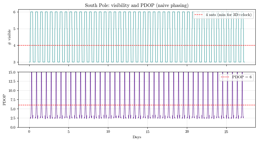
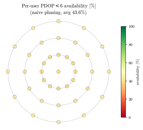
For every user and every epoch we count the visible satellites (elevation above the mask) and compute the PDOP. Availability is the fraction of user×time samples with PDOP < 6.
[8]:
avail0, pdop0 = const.availability(pos_pa, SERVICE_USERS, MASK_DEG, PDOP_THRESH)
nvis0 = const.n_visible(pos_pa, SERVICE_USERS, MASK_DEG)

print(f"Naive phasing (all offsets = 0):")
print(
    f"  PDOP < {PDOP_THRESH:.0f} availability : {avail0:.1f} %  (over service volume x 1 month)"
)
print(
    f"  median visible sats     : {np.median(nvis0):.0f}   (min {nvis0.min()}, max {nvis0.max()})"
)
print(f"  median PDOP (>=4 vis)    : {np.median(pdop0[pdop0 < DOP_INF]):.2f}")
Naive phasing (all offsets = 0):
  PDOP < 6 availability : 43.6 %  (over service volume x 1 month)
  median visible sats     : 5   (min 3, max 6)
  median PDOP (>=4 vis)    : 3.57
[9]:
# --- PDOP and #visible at the South Pole vs time -----------------------------
pole = SERVICE_USERS[:1]
pdop_pole = const.compute_pdop(pos_pa, pole, MASK_DEG)[0]
nvis_pole = const.n_visible(pos_pa, pole, MASK_DEG)[0]
t_days = (tfs - tfs[0]) / SECS_DAY

fig, (ax1, ax2) = plt.subplots(2, 1, figsize=(9, 5), sharex=True)
ax1.plot(t_days, nvis_pole, lw=0.8, color="teal")
ax1.axhline(4, color="red", ls="--", lw=1, label="4 sats (min for 3D+clock)")
ax1.set_ylabel("# visible")
ax1.legend(loc="upper right")
ax1.grid(alpha=0.3)
ax1.set_title("South Pole: visibility and PDOP (naive phasing)")
pdop_plot = np.where(pdop_pole < DOP_INF, pdop_pole, np.nan)
ax2.plot(t_days, pdop_plot, lw=0.8, color="indigo")
ax2.axhline(PDOP_THRESH, color="red", ls="--", lw=1, label=f"PDOP = {PDOP_THRESH:.0f}")
ax2.set_ylim(0, 15)
ax2.set_ylabel("PDOP")
ax2.set_xlabel("Days")
ax2.legend(loc="upper right")
ax2.grid(alpha=0.3)
plt.tight_layout()
plt.show()
[10]:
# --- Per-user availability map over the cap (naive phasing) ------------------
def availability_per_user(constellation, pos_pa, users, mask_deg, thr):
    pdop = constellation.compute_pdop(pos_pa, users, mask_deg)  # (n_user, T)
    return (pdop < thr).mean(axis=1) * 100.0


au0 = availability_per_user(const, pos_pa, SERVICE_USERS, MASK_DEG, PDOP_THRESH)

fig, ax = plt.subplots(figsize=(5.2, 4.6))
lat_d, lon_d = SERVICE_USERS[:, 0] * DEG, SERVICE_USERS[:, 1] * DEG
r = 90 + lat_d
sc = ax.scatter(
    r * np.sin(np.deg2rad(lon_d)),
    r * np.cos(np.deg2rad(lon_d)),
    c=au0,
    s=80,
    cmap="RdYlGn",
    vmin=0,
    vmax=100,
    edgecolors="k",
    linewidths=0.3,
)
for ring in (5, 10, 15):
    th = np.linspace(0, 2 * np.pi, 100)
    ax.plot(ring * np.cos(th), ring * np.sin(th), "k:", lw=0.5)
ax.set_aspect("equal")
ax.axis("off")
ax.set_title(
    f"Per-user PDOP$<${PDOP_THRESH:.0f} availability [%]\n(naive phasing, avg {au0.mean():.1f}%)"
)
plt.colorbar(sc, label="availability [%]", shrink=0.8)
plt.tight_layout()
plt.show()
6. Required EIRP over the service volume
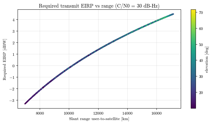
A navigation signal must arrive with enough carrier-to-noise density \(C/N_0\) to be tracked. Using a simple downlink budget at the LunaNet Augmented Forward Signal band (\(\sim2492\) MHz),
we compute the transmit EIRP each satellite needs to serve each visible user. The worst case (maximum required EIRP) sizes the payload; it occurs at the longest slant range — a user seeing a satellite near apolune on the far side of the cap.
[11]:
eirp_req, rng, elev = const.required_eirp(
    pos_pa, SERVICE_USERS, MASK_DEG, cn0_req_dbhz=30.0
)

finite = np.isfinite(eirp_req)
print(f"Required EIRP over the service volume (C/N0 = 30 dB-Hz, G_rx = 6 dBi):")
print(
    f"  min  : {np.nanmin(eirp_req):5.1f} dBW  ({10**(np.nanmin(eirp_req)/10):.2f} W)"
)
print(f"  95%  : {np.nanpercentile(eirp_req[finite], 95):5.1f} dBW")
print(
    f"  max  : {np.nanmax(eirp_req):5.1f} dBW  ({10**(np.nanmax(eirp_req)/10):.1f} W)  <-- sizes the payload"
)
print(
    f"  max slant range in view: {np.nanmax(np.where(finite, rng, np.nan))/1e3:.0f} km"
)

fig, ax = plt.subplots(figsize=(7.5, 4.2))
sc = ax.scatter(
    rng[finite] / 1e3, eirp_req[finite], c=elev[finite] * DEG, s=4, cmap="viridis"
)
ax.set_xlabel("Slant range user-to-satellite [km]")
ax.set_ylabel("Required EIRP [dBW]")
ax.set_title("Required transmit EIRP vs range (C/N0 = 30 dB-Hz)")
ax.grid(alpha=0.3)
plt.colorbar(sc, label="elevation [deg]")
plt.tight_layout()
plt.show()
Required EIRP over the service volume (C/N0 = 30 dB-Hz, G_rx = 6 dBi):
  min  :  -3.3 dBW  (0.46 W)
  95%  :   4.3 dBW
  max  :   4.5 dBW  (2.8 W)  <-- sizes the payload
  max slant range in view: 17140 km
7. Phasing optimization
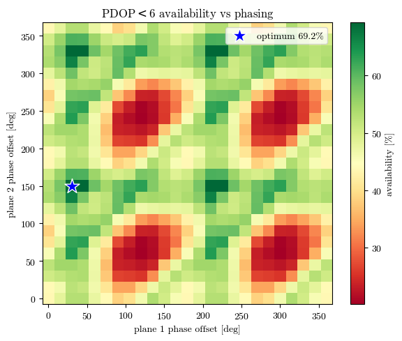
We now optimize the satellite phasing to maximize the PDOP < 6 availability over the whole service volume and the full month. By the constellation’s symmetry the free variables are the per-plane phase offsets; we fix plane 0 at \(0\) (a gauge choice, since a rigid shift of all planes is just a time shift) and optimize the remaining \(n_\text{planes}-1\) offsets.
Fast objective. Re-propagating for every candidate would be far too slow. Instead we exploit two facts of the two-body + resonant design:
the CI→PA rotation \(R(t)\) does not depend on phasing → precompute it once;
shifting a satellite’s mean anomaly by \(\Delta M\) is exactly a time shift \(\Delta t=\Delta M/n\) along its (inertially fixed) orbit → precompute each plane’s trajectory once over an extended grid and realize any phase offset as an index roll.
Each objective evaluation is then just array rolls, an einsum, and a batched \(4\times4\) inverse.
[12]:
class PhasingEvaluator:
    """Fast availability(plane_phase) evaluator for two-body resonant ELFO constellations."""

    def __init__(self, constellation, tfs, users, mask_deg=10.0, pdop_thresh=6.0):
        self.c = constellation
        self.tfs = np.asarray(tfs)
        self.users = users
        self.mask = np.deg2rad(mask_deg)
        self.thr = pdop_thresh
        self.lent = len(tfs)
        self.dt = tfs[1] - tfs[0]
        self.n = constellation.mean_motion
        self.steps_per_orbit = int(np.ceil(constellation.period / self.dt))

        # precompute CI->PA rotations over the assessment window
        self.R = np.array(
            [
                np.array(
                    pnt.get_frame_rotation_translation(t, pnt.MOON_CI, pnt.MOON_PA)[0]
                )[:3, :3]
                for t in self.tfs
            ]
        )  # (T,3,3)

        # precompute each plane's reference (M0=0) trajectory over an EXTENDED grid
        tfs_ext = (
            constellation.epoch + np.arange(self.lent + self.steps_per_orbit) * self.dt
        )
        dyn = pnt.CartesianTwoBodyDynamics(GM_MOON)
        self.plane_ci = []
        for p in range(constellation.n_planes):
            raan = constellation.raan0 + p * 2 * np.pi / constellation.n_planes
            coe = np.array(
                [
                    constellation.a,
                    constellation.e,
                    constellation.inc,
                    raan,
                    constellation.argp,
                    0.0,
                ]
            )
            rv0 = pnt.convert_frame(
                constellation.epoch,
                pnt.classical_to_cart(coe, GM_MOON),
                pnt.MOON_OP,
                pnt.MOON_CI,
            )
            self.plane_ci.append(np.asarray(dyn.propagate(rv0, tfs_ext))[:, :3])

        # precompute user positions and ENU frames
        self.r_user = np.array([lla_to_cart(u[0], u[1], u[2]) for u in users])
        self.R_enu = np.array([enu_matrix(u[0], u[1]) for u in users])

    def positions_pa(self, plane_phase):
        """Assemble (n_sat, T, 3) MOON_PA positions for the given per-plane phase offsets."""
        out = np.empty((self.c.n_sat, self.lent, 3))
        k = 0
        for p in range(self.c.n_planes):
            for s in range(self.c.sats_per_plane):
                phase = (s * 2 * np.pi / self.c.sats_per_plane + plane_phase[p]) % (
                    2 * np.pi
                )
                roll = int(round((phase / self.n) / self.dt)) % self.steps_per_orbit
                ci = self.plane_ci[p][roll : roll + self.lent]
                out[k] = np.einsum("kij,kj->ki", self.R, ci)
                k += 1
        return out

    def availability(self, plane_phase):
        pos = self.positions_pa(plane_phase)
        los = pos[None] - self.r_user[:, None, None, :]
        enu = np.einsum("uij,uslj->usli", self.R_enu, los)
        rng = np.linalg.norm(enu, axis=-1)
        elev = np.arcsin(np.clip(enu[..., 2] / rng, -1, 1))
        vis = elev >= self.mask
        u = np.moveaxis(enu / rng[..., None], 1, -2)  # (nu, T, ns, 3)
        v = np.moveaxis(vis, 1, -1)  # (nu, T, ns)
        pdop = batched_pdop(u, v)
        return float((pdop < self.thr).mean() * 100.0)


evaluator = PhasingEvaluator(const, tfs, SERVICE_USERS, MASK_DEG, PDOP_THRESH)

# sanity: fast evaluator must match the class computation for the naive phasing
fast0 = evaluator.availability(np.zeros(N_PLANES))
print(f"availability check  ->  class: {avail0:.1f}%   fast: {fast0:.1f}%")
availability check -> class: 43.6% fast: 43.6%
[13]:
# --- Optimization landscape: sweep the two free per-plane offsets ------------
grid = np.linspace(0, 2 * np.pi, 25)  # ~15-deg resolution
land = np.zeros((grid.size, grid.size))
for i, p1 in enumerate(grid):
    for j, p2 in enumerate(grid):
        land[i, j] = evaluator.availability([0.0, p1, p2])

imax = np.unravel_index(np.argmax(land), land.shape)
best_grid = np.array([0.0, grid[imax[0]], grid[imax[1]]])
print(
    f"Grid optimum: plane offsets = {best_grid*DEG} deg  ->  availability {land.max():.1f}%"
)
print(
    f"Landscape spans {land.min():.1f}% (worst) to {land.max():.1f}% (best) -- phasing matters a lot!"
)

fig, ax = plt.subplots(figsize=(6, 5))
im = ax.pcolormesh(grid * DEG, grid * DEG, land.T, cmap="RdYlGn", shading="auto")
ax.scatter(
    best_grid[1] * DEG,
    best_grid[2] * DEG,
    marker="*",
    s=250,
    color="blue",
    edgecolors="white",
    label=f"optimum {land.max():.1f}%",
)
ax.set_xlabel("plane 1 phase offset [deg]")
ax.set_ylabel("plane 2 phase offset [deg]")
ax.set_title(f"PDOP$<${PDOP_THRESH:.0f} availability vs phasing")
ax.legend(loc="upper right")
plt.colorbar(im, label="availability [%]")
plt.tight_layout()
plt.show()
Grid optimum: plane offsets = [  0.  30. 150.] deg  ->  availability 69.2%
Landscape spans 20.2% (worst) to 69.2% (best) -- phasing matters a lot!
[14]:
# --- Refine with a global optimizer (differential evolution) -----------------
def neg_availability(x):
    return -evaluator.availability(np.concatenate([[0.0], x]))


result = differential_evolution(
    neg_availability,
    bounds=[(0, 2 * np.pi)] * (N_PLANES - 1),
    maxiter=20,
    popsize=12,
    tol=1e-4,
    seed=0,
    polish=False,
)
best_phase = np.concatenate([[0.0], result.x])
avail_opt = -result.fun
print(f"Optimized plane offsets : {best_phase*DEG} deg")
print(f"Optimized availability  : {avail_opt:.1f} %   (naive was {avail0:.1f} %)")
Optimized plane offsets : [  0.     209.2636 328.0124] deg
Optimized availability  : 72.0 %   (naive was 43.6 %)
8. Optimized design — results and high-fidelity verification
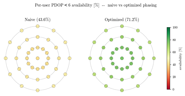
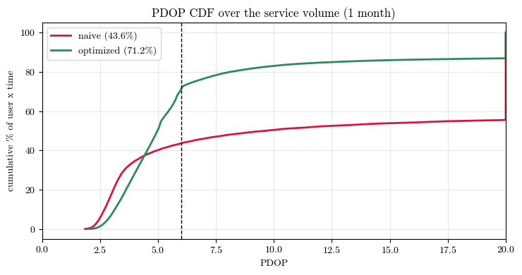
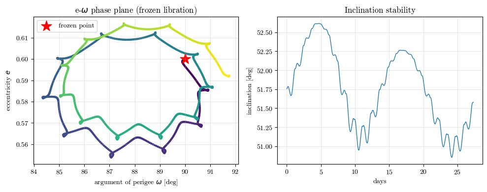
We apply the optimized phasing, recompute the coverage metrics, and compare with the naive design. Finally we verify the optimized constellation with full N-body dynamics (Moon 7×1 gravity + Earth + Sun third bodies) over the month — to see how the two-body–optimized availability fares under realistic perturbations (it drops somewhat, as the slow frozen libration reshapes the geometry away from the idealized two-body optimum, but stays well above the naive baseline) and to confirm the orbits remain frozen (bounded \(e\)–\(\omega\) libration). A production design would optimize the phasing directly on the N-body trajectories using the same objective.
[15]:
const.set_phasing(best_phase)
pos_opt = const.propagate(tfs, model="twobody")
avail_opt2, pdop_opt = const.availability(pos_opt, SERVICE_USERS, MASK_DEG, PDOP_THRESH)
au_opt = availability_per_user(const, pos_opt, SERVICE_USERS, MASK_DEG, PDOP_THRESH)

# side-by-side per-user availability maps: naive vs optimized
fig, axes = plt.subplots(1, 2, figsize=(10, 4.6))
for ax, au, title in [
    (axes[0], au0, f"Naive ({au0.mean():.1f}%)"),
    (axes[1], au_opt, f"Optimized ({au_opt.mean():.1f}%)"),
]:
    r = 90 + SERVICE_USERS[:, 0] * DEG
    lon_d = SERVICE_USERS[:, 1] * DEG
    sc = ax.scatter(
        r * np.sin(np.deg2rad(lon_d)),
        r * np.cos(np.deg2rad(lon_d)),
        c=au,
        s=90,
        cmap="RdYlGn",
        vmin=0,
        vmax=100,
        edgecolors="k",
        linewidths=0.3,
    )
    for ring in (5, 10, 15):
        th = np.linspace(0, 2 * np.pi, 100)
        ax.plot(ring * np.cos(th), ring * np.sin(th), "k:", lw=0.5)
    ax.set_aspect("equal")
    ax.axis("off")
    ax.set_title(title)
fig.suptitle(
    f"Per-user PDOP$<${PDOP_THRESH:.0f} availability [%]  --  naive vs optimized phasing"
)
plt.colorbar(sc, ax=axes, label="availability [%]", shrink=0.7)
plt.show()
[16]:
# --- PDOP distribution: naive vs optimized -----------------------------------
fig, ax = plt.subplots(figsize=(7.5, 4))
for pd, lab, col in [
    (pdop0, f"naive ({avail0:.1f}%)", "crimson"),
    (pdop_opt, f"optimized ({avail_opt2:.1f}%)", "seagreen"),
]:
    vals = np.sort(pd.ravel())
    cdf = np.arange(1, vals.size + 1) / vals.size * 100
    ax.plot(np.clip(vals, 0, 20), cdf, lw=2, label=lab, color=col)
ax.axvline(PDOP_THRESH, color="k", ls="--", lw=1)
ax.set_xlabel("PDOP")
ax.set_ylabel("cumulative % of user x time")
ax.set_title("PDOP CDF over the service volume (1 month)")
ax.set_xlim(0, 20)
ax.legend()
ax.grid(alpha=0.3)
plt.tight_layout()
plt.show()
[17]:
# --- High-fidelity verification: full N-body over one month ------------------
print(
    "Propagating optimized constellation with full N-body dynamics (this takes ~1 min)..."
)
pos_nbody = const.propagate(tfs, model="nbody", moon_deg_ord=(7, 1))
avail_nb, pdop_nb = const.availability(pos_nbody, SERVICE_USERS, MASK_DEG, PDOP_THRESH)
print(f"Availability  ->  two-body: {avail_opt2:.1f} %    N-body: {avail_nb:.1f} %")
Propagating optimized constellation with full N-body dynamics (this takes ~1 min)...
Availability  ->  two-body: 71.2 %    N-body: 60.3 %
[18]:
# --- Confirm the orbits stay frozen: e-omega libration (N-body, in MOON_OP) --
sat0 = const.initial_states_ci()[0]
dynN = const._make_dynamics("nbody", (7, 1))
rv_ci = np.asarray(dynN.propagate(sat0, tfs))
rv_op = pnt.convert_frame(tfs, rv_ci, pnt.MOON_CI, pnt.MOON_OP)
coe_op = np.array([pnt.cart_to_classical(rv_op[k], GM_MOON) for k in range(len(tfs))])

fig, (ax1, ax2) = plt.subplots(1, 2, figsize=(10, 4))
ax1.scatter(coe_op[:, 4] * DEG, coe_op[:, 1], c=t_days, cmap="viridis", s=5)
ax1.scatter([90], [ECC], marker="*", s=250, color="red", label="frozen point")
ax1.set_xlabel("argument of perigee $\\omega$ [deg]")
ax1.set_ylabel("eccentricity $e$")
ax1.set_title("e-$\\omega$ phase plane (frozen libration)")
ax1.legend()
ax1.grid(alpha=0.3)
ax2.plot(t_days, coe_op[:, 2] * DEG, lw=1)
ax2.set_xlabel("days")
ax2.set_ylabel("inclination [deg]")
ax2.set_title("Inclination stability")
ax2.grid(alpha=0.3)
plt.tight_layout()
plt.show()
9. Summary
This notebook used LuPNT as a constellation-design sandbox:
an ELFO family was selected from resonance and frozen-orbit conditions;
a six-satellite, three-plane Walker-style constellation was generated;
south-pole user coverage, PDOP availability, and required EIRP were evaluated over a sidereal month;
per-plane phasing was optimized with a fast time-shift objective;
the optimized design was checked again with higher-fidelity N-body propagation.
The same framework can be extended by adding more satellites, changing the service volume, using weighted DOP from link-budget-derived measurement noise, or adding station-keeping cost as a second objective.