Example 5: GNSS Measurement Simulation for a Lunar Satellite
This tutorial simulates which Earth GNSS signals a lunar-orbiting receiver can track. It bridges the GNSS data interfaces from Example 3 and the plasma/link geometry from Example 4 to produce measurement-ready visibility and carrier-to-noise histories.
Workflow:
define and propagate a lunar ELFO receiver trajectory;
load GPS and Galileo precise ephemerides with
SP3Loader;build a C++
GnssConstellationobject from those transmitter states;run
GNSSMeasurements.precompute()to evaluate line of sight, antenna gain, free-space loss, and \(C/N_0\);visualize tracked satellites, signal strength, and transmit-antenna directions.
The basic observable is pseudorange,
but this notebook focuses on the geometry and link budget needed before noisy observations are generated.
[1]:
import numpy as np
import matplotlib.pyplot as plt
import matplotlib.cm as cm
import matplotlib.colors as mcolors
from collections import Counter
from datetime import datetime, timezone

import os, sys
from pathlib import Path

# Use THIS repo's pylupnt/data, not a stale copy on a global PYTHONPATH (~/.zshrc) or kernelspec.
for _b in [Path.cwd(), *Path.cwd().parents]:
    if (_b / "python/pylupnt/__init__.py").exists():
        sys.path.insert(0, str((_b / "python").resolve()))
        if (_b / "data/LuPNT_data/ephemeris").is_dir():
            os.environ["LUPNT_DATA_PATH"] = str((_b / "data/LuPNT_data").resolve())
        break
import pylupnt as pnt
[00.01][PyLuPNT] Initializing
1. Simulation epoch
The epoch selects both the lunar receiver state and the GNSS product files. Precise SP3 products are time-tagged, so the transmitter and receiver timelines must overlap.
[2]:
t0_tdb = pnt.gregorian_to_time(2026, 1, 1, 0, 0, 0.0)
t0_tai = pnt.convert_time(t0_tdb, pnt.TDB, pnt.TAI)
print(f"Epoch (TDB): {pnt.time_to_gregorian_string(t0_tdb)} TDB")
print(f"t0_tdb={t0_tdb:.3f} s  t0_tai={t0_tai:.3f} s")
Epoch (TDB): 2026-01-01T00:00:00.000 TDB
t0_tdb=820497600.000 s  t0_tai=820497567.816 s
2. ELFO definition
The receiver is placed in the same ELFO family used throughout the tutorials. Classical elements provide a compact design description before conversion to Cartesian state for propagation.
[3]:
a = 6541.4e3
e = 0.6
i = 56.2 * pnt.RAD
raan = 0.0 * pnt.RAD
w = 90.0 * pnt.RAD
M0 = 0.0 * pnt.RAD

coe0_op = np.array([a, e, i, raan, w, M0])
period = float(pnt.get_orbital_period(a, pnt.GM_MOON))
print(f"Orbital period: {period:.1f} s  ({period/pnt.SECS_HOUR:.2f} h)")

rv0_op = pnt.classical_to_cart(coe0_op, pnt.GM_MOON)
rv0_mci = pnt.convert_frame(t0_tdb, rv0_op, pnt.MOON_OP, pnt.MOON_CI)
print(f"r0 (MCI): {rv0_mci[:3]/1e3} km")
Orbital period: 47474.9 s  (13.19 h)
r0 (MCI): [ 410.80116383  178.48187281 2577.93965377] km
3. Multibody dynamics setup
The receiver trajectory is propagated with lunar gravity and third-body perturbations. Accurate receiver geometry matters because GNSS visibility at lunar distance is sensitive to occultation and off-boresight antenna angles.
[4]:
dyn = pnt.NBodyDynamics()
dyn.set_frame(pnt.MOON_CI)
dyn.set_units(pnt.SI_UNITS)
dyn.add_body(pnt.create_body(pnt.MOON, 2, 2))
dyn.add_body(pnt.create_body(pnt.EARTH))
dyn.add_body(pnt.create_body(pnt.SUN))
dyn.set_srp_coeff(1.8, 0.02, 10.0)
dyn.set_integrator(pnt.IntegratorType.RKF45)
params = pnt.IntegratorParams()
params.reltol = 1e-10
params.abstol = 1e-6
dyn.set_integrator_params(params)
4. Propagate the ELFO for one orbital period
One full orbital period is long enough to see how visibility changes between perilune, apolune, near-side, and far-side geometry.
[5]:
DT_RX = 300.0
N_RX = int(period / DT_RX) + 1
t_tdb_arr = t0_tdb + np.arange(N_RX) * DT_RX
t_tai_arr = pnt.convert_time(t_tdb_arr, pnt.TDB, pnt.TAI)
t_hrs = (t_tai_arr - t_tai_arr[0]) / pnt.SECS_HOUR

rv_mci = np.array(dyn.propagate(rv0_mci, t_tdb_arr))
print(
    f"Propagated {N_RX} epochs ({DT_RX:.0f}-s steps) over {period/pnt.SECS_HOUR:.2f} h"
)
Propagated 159 epochs (300-s steps) over 13.19 h
[6]:
# Convert MCI -> ECI for GNSS measurement model
rv_eci = np.array(pnt.convert_frame(t_tdb_arr, rv_mci, pnt.MOON_CI, pnt.ECI))

# 8-element state [r, v, clock_bias=0, clock_drift=0]
rx_states_eci = np.hstack([rv_eci, np.zeros((N_RX, 2))])

alt_km = (np.linalg.norm(rv_mci[:, :3], axis=1) - pnt.R_MOON) / 1e3
print(f"Apoapsis: {alt_km.max():.0f} km above Moon surface")
print(f"Periapsis: {alt_km.min():.0f} km above Moon surface")
Apoapsis: 8727 km above Moon surface
Periapsis: 879 km above Moon surface
5. Load GPS and Galileo constellations from SP3 files
SP3Loader downloads or reuses cached COD MGEX precise ephemerides. We query GPS (G) and Galileo (E) transmitter states on a regular grid and pass those samples into the C++ constellation object used by the measurement engine.
[7]:
from datetime import timedelta

START_DT = datetime(2026, 1, 1, tzinfo=timezone.utc)
SIM_T_S = period + 3600
n_days = int(np.ceil(SIM_T_S / 86400.0))


def _day_epoch_tai(d):
    """Mid-day TAI epoch for a calendar day (used to pick that day's SP3 product)."""
    t_tdb = pnt.gregorian_to_time(d.year, d.month, d.day, 12, 0, 0)
    return pnt.convert_time(t_tdb, pnt.Time.TDB, pnt.Time.TAI)


def query_sp3_eci(loader, sat_id, t_tai_arr, t_tdb_arr):
    """Evaluate the C++ Sp3Loader over a grid: scalar-t ECEF states → ECI [N x 6].

    Epochs the loader can't cover are returned as NaN (skipped downstream)."""
    n = len(t_tai_arr)
    rv_ecef = np.full((n, 6), np.nan)
    for k in range(n):
        try:
            rv, _ = loader.get_pos_vel_clock(sat_id, float(t_tai_arr[k]))
            rv_ecef[k] = np.asarray(rv, dtype=float)
        except RuntimeError:
            pass
    return np.asarray(pnt.convert_frame(t_tdb_arr, rv_ecef, pnt.ECEF, pnt.ECI))


# LuPNT's C++ Sp3Loader downloads the COD MGEX final products from NASA CDDIS
# (Earthdata Login required; cached under output/gnss_files/sp3) and parses them.
print("Downloading/loading SP3 files (COD MGEX final) via the C++ Sp3Loader…")
sp3_paths = []
for k in range(-1, n_days + 1):  # +/- 1 day of margin around the arc
    d = (START_DT + timedelta(days=k)).date()
    sp3_paths.append(pnt.Sp3Loader.download_file_for_epoch(_day_epoch_tai(d), pnt.Time.TAI))
sp3 = pnt.Sp3Loader(sp3_paths)
print(f"Loaded {len(sp3.get_satellites())} satellites")
Downloading/loading SP3 files (COD MGEX final) via the C++ Sp3Loader…
Loaded 123 satellites
[8]:
DT_SAT = 300.0
# Start one step before t0_tai: light-time iteration queries the GPS satellite
# at t_tx = t_rx - range/c (~1.3 s for cislunar distances), so the fit must cover
# slightly before the first receiver epoch.
MARGIN_S = DT_SAT
N_SAT = int((SIM_T_S + MARGIN_S) / DT_SAT) + 1
t_sat_tai = (t0_tai - MARGIN_S) + np.arange(N_SAT) * DT_SAT
t_sat_tdb = pnt.convert_time(t_sat_tai, pnt.Time.TAI, pnt.Time.TDB)

gps_prns_sp3 = sorted(int(s[1:]) for s in sp3.get_satellites() if s.startswith("G"))
print(f"GPS PRNs in SP3: {gps_prns_sp3}")

rv_eci_list = []
valid_prns = []
for prn in gps_prns_sp3:
    sat_id = f"G{prn:02d}"
    if not sp3.has_satellite(sat_id):
        continue
    rv_sat = query_sp3_eci(sp3, sat_id, t_sat_tai, t_sat_tdb)
    if np.isnan(rv_sat).any():
        print(f"  {sat_id}: skipped (incomplete SP3 coverage over the arc)")
        continue
    rv_eci_list.append(rv_sat)
    valid_prns.append(prn)

print(f"Queried {len(valid_prns)} GPS satellites")
GPS PRNs in SP3: [1, 2, 3, 4, 5, 6, 7, 8, 9, 10, 11, 12, 13, 14, 15, 16, 17, 18, 19, 20, 21, 22, 23, 24, 25, 26, 27, 28, 29, 30, 31, 32]
Queried 32 GPS satellites
[9]:
gal_prns_sp3 = sorted(int(s[1:]) for s in sp3.get_satellites() if s.startswith("E"))
print(f"Galileo PRNs in SP3: {gal_prns_sp3}")

gal_rv_eci_list = []
gal_valid_prns = []
for prn in gal_prns_sp3:
    sat_id = f"E{prn:02d}"
    if not sp3.has_satellite(sat_id):
        continue
    rv_sat = query_sp3_eci(sp3, sat_id, t_sat_tai, t_sat_tdb)
    if np.isnan(rv_sat).any():
        print(f"  {sat_id}: skipped (incomplete SP3 coverage over the arc)")
        continue
    gal_rv_eci_list.append(rv_sat)
    gal_valid_prns.append(prn)

print(f"Queried {len(gal_valid_prns)} Galileo satellites")
Galileo PRNs in SP3: [2, 3, 4, 5, 6, 7, 8, 9, 10, 11, 12, 13, 14, 15, 18, 19, 21, 23, 25, 26, 27, 29, 30, 31, 33, 34, 36]
Queried 27 Galileo satellites
6. Build the C++ GnssConstellation
GnssConstellation stores transmitter trajectories and metadata in the format expected by LuPNT’s measurement models. This separates file parsing from the later link-budget calculation.
[10]:
gps_const = pnt.GnssConstellation(pnt.GnssConst.GPS)
gps_const.set_satellite_states(valid_prns, t_sat_tai, rv_eci_list)
print(f"GnssConstellation: {gps_const.get_num_satellites()} satellites")

# Load GPS transmit antenna patterns and power
has_tx_info = False
try:
    gps_const.setup_transmitters()
    has_tx_info = gps_const.has_transmitter_info(valid_prns[0], pnt.GnssFreq.L1)
    print(f"Transmitter info loaded: {has_tx_info}")
except Exception as ex:
    print(f"Warning: setup_transmitters() failed ({ex}); CN0 computation disabled")
GnssConstellation: 32 satellites
Transmitter info loaded: True
[11]:
gal_const = pnt.GnssConstellation(pnt.GnssConst.GALILEO)
gal_const.set_satellite_states(gal_valid_prns, t_sat_tai, gal_rv_eci_list)
print(f"Galileo GnssConstellation: {gal_const.get_num_satellites()} satellites")

has_gal_tx_info = False
try:
    gal_const.setup_transmitters()
    has_gal_tx_info = gal_const.has_transmitter_info(gal_valid_prns[0], pnt.GnssFreq.E1)
    print(f"Galileo transmitter info loaded: {has_gal_tx_info}")
except Exception as ex:
    print(f"Warning: Galileo setup_transmitters() failed ({ex})")
Galileo GnssConstellation: 27 satellites
Galileo transmitter info loaded: True
7. Configure GNSSMeasurements
The measurement object combines receiver trajectory, transmitter constellation, antenna patterns, occultation checks, and link-budget settings. Its precompute step produces the deterministic geometry used by filters such as Example 6.
[12]:
opts = pnt.GnssMeasurementOptions()
opts.frame = pnt.ECI
opts.receive_time_scale = pnt.TAI
opts.ephemeris_time_scale = pnt.TAI
opts.solve_light_time = True
opts.apply_transmitter_relativity = True
opts.apply_shapiro_delay = False
opts.apply_visibility = True
opts.apply_cn0_threshold = True
opts.cn0_acquisition_threshold_dbhz = 22.0
opts.cn0_tracking_threshold_dbhz = 20.0
opts.apply_ionosphere_plasma_delay = False

earth_body = pnt.GnssOccludingBody()
earth_body.radius_m = pnt.R_EARTH

# Moon moves ~7 deg over the ELFO period; position_provider is called per
# epoch inside BuildChannels — no manual update needed in the loop.
moon_body = pnt.GnssOccludingBody()
moon_body.radius_m = pnt.R_MOON
moon_body.position_provider = lambda t_tai: np.array(
    pnt.get_body_pos(
        float(pnt.convert_time(t_tai, pnt.TAI, pnt.TDB)), pnt.EARTH, pnt.MOON, pnt.ECI
    )
)

rx_params = pnt.GnssReceiverParams()
rx_params.Bp = 1.0
rx_params.Bn = 0.7
rx_params.T = 20e-3

rx_antenna = pnt.Antenna("moongpsr")  # Earth-pointing dish, +14 dBi, ±7 deg HPBW


def sun_pos_eci(t_tai):
    t_tdb = float(pnt.convert_time(t_tai, pnt.TAI, pnt.TDB))
    return np.array(pnt.get_body_pos(t_tdb, pnt.EARTH, pnt.SUN, pnt.ECI))


def earth_pos_eci(t_tai):
    return np.zeros(3)  # Earth at ECI origin (boresight for moongpsr)


# Single GNSSMeasurements handles GPS L1 + Galileo E1 together.
gnss_meas = pnt.GNSSMeasurements(gps_const)
gnss_meas.set_frequency(pnt.GnssFreq.L1)
gnss_meas.add_constellation(gal_const, pnt.GnssFreq.E1)
gnss_meas.set_options(opts)
gnss_meas.set_receiver_params(rx_params)
gnss_meas.set_receiver_antenna(rx_antenna)
gnss_meas.set_occluding_bodies([earth_body, moon_body])
gnss_meas.set_sun_position_provider(sun_pos_eci)
gnss_meas.set_boresight_target_provider(earth_pos_eci)

print("GNSSMeasurements configured (GPS L1 + Galileo E1, Earth + Moon occultation)")
print(f"Receiver antenna: {rx_antenna.name}")
GNSSMeasurements configured (GPS L1 + Galileo E1, Earth + Moon occultation)
Receiver antenna: moongpsr
8. Precompute visibility and \(C/N_0\)
For each receiver epoch and transmitter, LuPNT checks whether the signal path clears the Earth and Moon, evaluates the transmitter antenna gain in the satellite body frame, computes free-space path loss, and reports carrier-to-noise density.
[13]:
class _Epoch:
    __slots__ = ("receive_time", "channels")

    def __init__(self, t, ch):
        self.receive_time = t
        self.channels = ch


states_list = [rx_states_eci[i] for i in range(N_RX)]

print(f"Running per-epoch measurement loop for {N_RX} epochs...")

epoch_results = []
for t_tai, state in zip(t_tai_arr.tolist(), states_list):
    channels = gnss_meas.build_channels(t_tai, state)
    epoch_results.append(_Epoch(t_tai, channels))

print(f"Done. {len(epoch_results)} epoch results.")
Running per-epoch measurement loop for 159 epochs...
Done. 159 epoch results.
9. Extract results
The precompute result is organized into arrays indexed by time and satellite. We extract the fields needed for plotting: visible-link counts, \(C/N_0\), transmitter identifiers, and antenna-frame directions.
[14]:
n_vis = np.array([len(ep.channels) for ep in epoch_results])
n_gps_vis = np.array(
    [
        sum(1 for ch in ep.channels if ch.gnss_const == pnt.GnssConst.GPS)
        for ep in epoch_results
    ]
)
n_gal_vis = np.array(
    [
        sum(1 for ch in ep.channels if ch.gnss_const == pnt.GnssConst.GALILEO)
        for ep in epoch_results
    ]
)

# Use ch.gnss_const (not PRN number) to tag constellation — Galileo PRNs
# 2–31 overlap with GPS PRNs, so PRN-based tagging silently miscounts.
links = []
for i, ep in enumerate(epoch_results):
    for ch in ep.channels:
        const = "G" if ch.gnss_const == pnt.GnssConst.GPS else "E"
        links.append((t_hrs[i], f"{const}{ch.prn:02d}", float(ch.cn0_dbhz)))

links = np.array(links, dtype=object) if links else np.empty((0, 3))

n_gps_links = sum(1 for l in links if str(l[1]).startswith("G"))
n_gal_links = sum(1 for l in links if str(l[1]).startswith("E"))
print(
    f"Total visible links: {len(links)}  (GPS: {n_gps_links}, Galileo: {n_gal_links})"
)
print(f"Mean visible satellites: {n_vis.mean():.1f}")
if len(links) > 0:
    cn0_all = [float(l[2]) for l in links if np.isfinite(float(l[2]))]
    if cn0_all:
        print(f"C/N0 range: {min(cn0_all):.1f} - {max(cn0_all):.1f} dB-Hz")
Total visible links: 844  (GPS: 657, Galileo: 187)
Mean visible satellites: 5.3
C/N0 range: 20.0 - 44.9 dB-Hz
10. Plot 1: number of visible GNSS satellites
This time history shows when the lunar receiver has enough simultaneous transmitters for navigation. Dips usually correspond to occultation, poor antenna sidelobe geometry, or weak received power.
[15]:
fig, ax = plt.subplots(2, 1, figsize=(10, 6))

# gps
ax[0].step(t_hrs, n_gps_vis, where="post", color="steelblue", linewidth=1.5)
ax[0].fill_between(t_hrs, n_gps_vis, step="post", alpha=0.2, color="steelblue")
ax[0].set_xlabel("Time from epoch [h]")
ax[0].set_ylabel("# Visible GPS satellites")
ax[0].set_title("GPS Visibility — ELFO (2026-01-01, C/N0 \u2265 22 dB-Hz)")
ax[0].set_xlim(0, t_hrs[-1])
ax[0].set_ylim(bottom=0)
ax[0].grid(True, alpha=0.3)

ax[1].step(t_hrs, n_gal_vis, where="post", color="darkorange", linewidth=1.5)
ax[1].fill_between(t_hrs, n_gal_vis, step="post", alpha=0.2, color="darkorange")
ax[1].set_xlabel("Time from epoch [h]")
ax[1].set_ylabel("# Visible Galileo satellites")
ax[1].set_title("Galileo Visibility — ELFO (2026-01-01, C/N0 \u2265 22 dB-Hz)")
ax[1].set_xlim(0, t_hrs[-1])
ax[1].set_ylim(bottom=0)
ax[1].grid(True, alpha=0.3)

plt.tight_layout()
plt.show()
print(f"Peak: {n_vis.max()} sats,  Min: {n_vis.min()} sats")
/var/folders/1f/_8g3y5td38n93nph4z3c5d4c0000gn/T/ipykernel_23103/2768200746.py:22: UserWarning: Glyph 8212 (\N{EM DASH}) missing from font(s) cmr10.
  plt.tight_layout()
/var/folders/1f/_8g3y5td38n93nph4z3c5d4c0000gn/T/ipykernel_23103/2768200746.py:22: UserWarning: Glyph 8805 (\N{GREATER-THAN OR EQUAL TO}) missing from font(s) cmr10.
  plt.tight_layout()
/Users/keidaiiiyama/Documents/sw_navlab/LuPNT/.pixi/envs/default/lib/python3.11/site-packages/IPython/core/pylabtools.py:170: UserWarning: Glyph 8212 (\N{EM DASH}) missing from font(s) cmr10.
  fig.canvas.print_figure(bytes_io, **kw)
/Users/keidaiiiyama/Documents/sw_navlab/LuPNT/.pixi/envs/default/lib/python3.11/site-packages/IPython/core/pylabtools.py:170: UserWarning: Glyph 8805 (\N{GREATER-THAN OR EQUAL TO}) missing from font(s) cmr10.
  fig.canvas.print_figure(bytes_io, **kw)
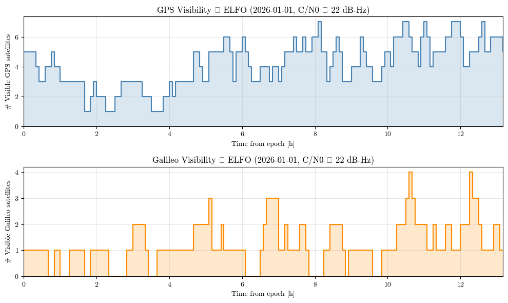
Peak: 10 sats, Min: 1 sats
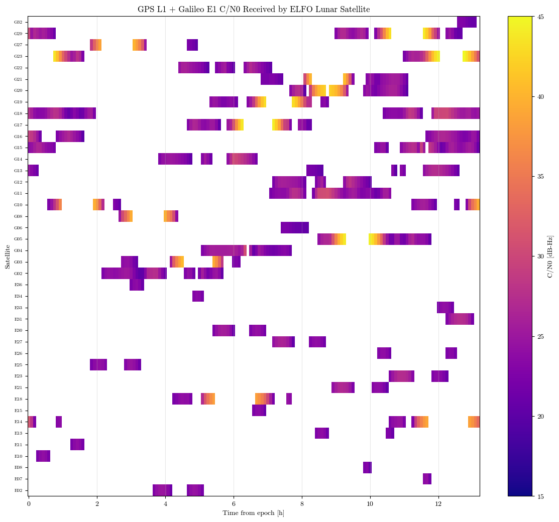
11. Plot 2: \(C/N_0\) heat map
The heat map shows signal strength by satellite and time. It is often more informative than a visible-count plot because a barely tracked sidelobe and a strong link have very different measurement noise.
[16]:
if len(links) > 0:
    all_sats = sorted(set(str(l[1]) for l in links), key=lambda s: (s[0], int(s[1:])))
    sat_to_row = {s: r for r, s in enumerate(all_sats)}

    cn0_grid = np.full((len(all_sats), N_RX), np.nan)
    for t_hr, sat_id, cn0 in links:
        col = int(np.argmin(np.abs(t_hrs - float(t_hr))))
        cn0_grid[sat_to_row[str(sat_id)], col] = float(cn0)

    fig, ax = plt.subplots(figsize=(12, max(4, len(all_sats) * 0.25)))
    im = ax.pcolormesh(
        t_hrs,
        range(len(all_sats)),
        cn0_grid,
        cmap="plasma",
        vmin=15,
        vmax=45,
        shading="nearest",
    )
    plt.colorbar(im, ax=ax, label="C/N0 [dB-Hz]")
    ax.set_xlabel("Time from epoch [h]")
    ax.set_ylabel("Satellite")
    ax.set_title("GPS L1 + Galileo E1 C/N0 Received by ELFO Lunar Satellite")
    ax.set_yticks(range(len(all_sats)))
    ax.set_yticklabels(all_sats, fontsize=7)
    ax.grid(True, axis="x", alpha=0.3)
    plt.tight_layout()
    plt.show()
else:
    print("No visible links.")
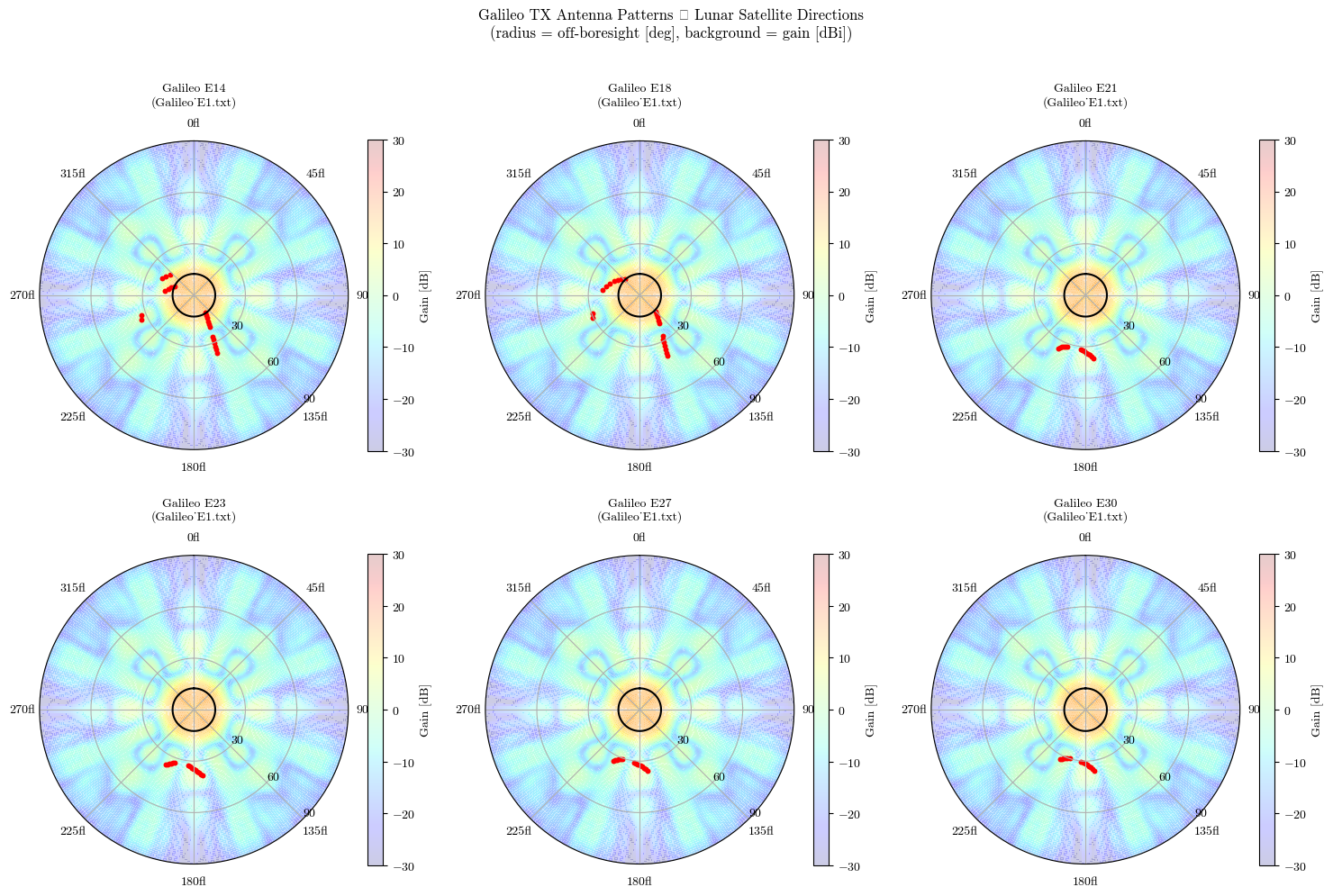
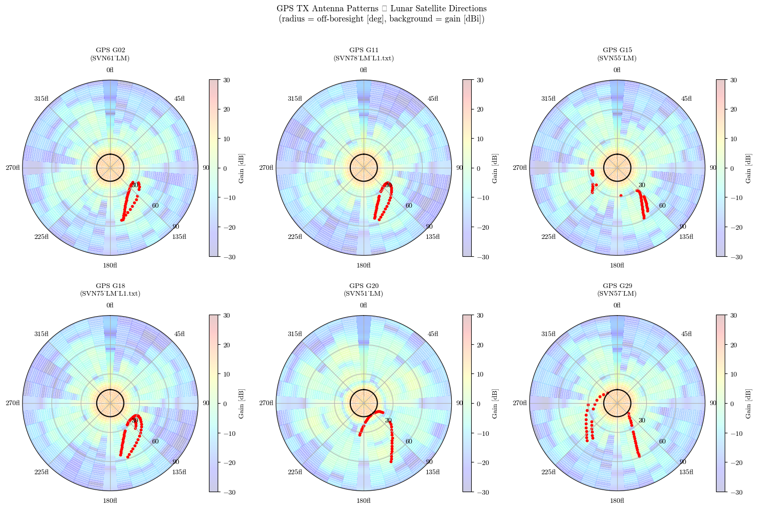
12. Plot 3: lunar-receiver directions on transmit antenna patterns
For each visible link, the receiver direction is projected into the GNSS transmitter’s antenna frame. Points far from boresight confirm that lunar GNSS reception usually relies on sidelobes rather than the Earth-facing main beam.
[17]:
# Project every visible link into the corresponding TX attitude frame.
# link_angles entries: (const, prn, phi_deg=off-boresight, theta_deg=azimuth, cn0, t_hr)
link_angles = []

for i, ep in enumerate(epoch_results):
    t_tai_i = float(ep.receive_time)
    t_tdb_i = float(pnt.convert_time(t_tai_i, pnt.TAI, pnt.TDB))
    rx_pos = rv_eci[i, :3]
    sun_pos = np.array(pnt.get_body_pos(t_tdb_i, pnt.EARTH, pnt.SUN, pnt.ECI))

    for ch in ep.channels:
        prn = ch.prn
        # Use gnss_const — PRN numbers overlap between GPS (1–32) and Galileo (1–36)
        const = "G" if ch.gnss_const == pnt.GnssConst.GPS else "E"
        tx_pos = np.array(ch.tx_state[:3])
        att = pnt.GnssAttitude(tx_pos, sun_pos)
        u = rx_pos - tx_pos
        u /= np.linalg.norm(u)
        theta_r, phi_r = att.get_angles(np.array(u))  # theta=azimuth, phi=off-boresight
        link_angles.append(
            (
                const,
                prn,
                float(np.degrees(phi_r)),  # off-boresight [deg]
                float(np.degrees(theta_r)),  # azimuth [deg]
                float(ch.cn0_dbhz),
                t_hrs[i],
            )
        )

print(f"Computed direction angles for {len(link_angles)} links")
Computed direction angles for 844 links
[18]:
def plot_antenna_polar(ax, antenna, cmap="jet", title=None):
    phi = np.array(antenna.get_phi_vector())
    theta = np.array(antenna.get_theta_vector())
    gain = np.array(antenna.get_gain_matrix())
    mask = phi >= 0
    phi = phi[mask]
    gain = gain[mask, :]
    T, P = np.meshgrid(np.radians(theta), phi)
    mesh = ax.pcolormesh(
        T, P, gain, cmap=cmap, shading="auto", vmin=-30, vmax=30, alpha=0.2
    )
    ax.set_theta_zero_location("N")
    ax.set_theta_direction(-1)
    ax.set_rlim(0, 90)
    ax.set_rticks([30, 60, 90])
    ax.set_rlabel_position(135)
    if title:
        ax.set_title(title, pad=10, fontsize=9)
    return mesh


gps_sma = 26560e3
gal_sma = 29600e3
earth_half_ang_deg_gps = np.degrees(np.arcsin(pnt.R_EARTH / gps_sma))
earth_half_ang_deg_gal = np.degrees(np.arcsin(pnt.R_EARTH / gal_sma))
_theta_circle = np.linspace(0, 2 * np.pi, 360)

if len(link_angles) == 0:
    print("No links to display.")
else:
    gps_links = [(a[1], a[2], a[3], a[4]) for a in link_angles if a[0] == "G"]
    gal_links = [(a[1], a[2], a[3], a[4]) for a in link_angles if a[0] == "E"]

    for const_label, const_links, constellation, freq, has_tx in [
        ("GPS", gps_links, gps_const, pnt.GnssFreq.L1, has_tx_info),
        ("Galileo", gal_links, gal_const, pnt.GnssFreq.E1, has_gal_tx_info),
    ]:
        if not const_links:
            print(f"No {const_label} links.")
            continue

        prn_counts = Counter(a[0] for a in const_links)
        display_prns = sorted(prn for prn, _ in prn_counts.most_common(6))
        print(f"{const_label}: displaying PRNs {display_prns}")

        ncols = 3
        nrows = int(np.ceil(len(display_prns) / ncols))
        fig, axes = plt.subplots(
            nrows,
            ncols,
            figsize=(5 * ncols, 5 * nrows),
            subplot_kw={"projection": "polar"},
        )
        axes = np.array(axes).ravel()

        for idx, prn in enumerate(display_prns):
            ax = axes[idx]
            ant_name = ""
            if has_tx and constellation.has_transmitter_info(prn, freq):
                ant = constellation.get_transmitter_antenna(prn, freq)
                ant_name = ant.name
                mesh = plot_antenna_polar(ax, ant, cmap="jet")
                cbar = fig.colorbar(mesh, ax=ax, shrink=0.8)
                cbar.set_label("Gain [dB]", fontsize=10)

            earth_half_ang_deg = (
                earth_half_ang_deg_gps
                if const_label == "GPS"
                else earth_half_ang_deg_gal
            )
            ax.plot(
                _theta_circle,
                np.full(360, earth_half_ang_deg),
                "k-",
                linewidth=1.5,
                zorder=4,
            )

            prn_data = [(a[1], a[2], a[3]) for a in const_links if a[0] == prn]
            if prn_data:
                phi_d, th_d, cn0_d = zip(*prn_data)
                ax.scatter(np.radians(th_d), phi_d, color="red", s=18, linewidths=0)

            ax.set_theta_zero_location("N")
            ax.set_theta_direction(-1)
            ax.set_rlim(0, 90)
            ax.set_rticks([30, 60, 90])
            ax.set_rlabel_position(135)
            prefix = "G" if const_label == "GPS" else "E"
            title_str = f"{const_label} {prefix}{prn:02d}"
            if ant_name:
                title_str += f"\n({ant_name})"
            ax.set_title(title_str, pad=10, fontsize=10)

        for idx in range(len(display_prns), len(axes)):
            axes[idx].set_visible(False)

        fig.suptitle(
            f"{const_label} TX Antenna Patterns — Lunar Satellite Directions\n"
            "(radius = off-boresight [deg], background = gain [dBi])",
            fontsize=12,
            y=1.01,
        )
        plt.tight_layout()
        plt.show()
GPS: displaying PRNs [2, 11, 15, 18, 20, 29]
/var/folders/1f/_8g3y5td38n93nph4z3c5d4c0000gn/T/ipykernel_23103/2511824198.py:104: UserWarning: Glyph 8212 (\N{EM DASH}) missing from font(s) cmr10.
  plt.tight_layout()
/Users/keidaiiiyama/Documents/sw_navlab/LuPNT/.pixi/envs/default/lib/python3.11/site-packages/IPython/core/pylabtools.py:170: UserWarning: Glyph 8212 (\N{EM DASH}) missing from font(s) cmr10.
  fig.canvas.print_figure(bytes_io, **kw)
Galileo: displaying PRNs [14, 18, 21, 23, 27, 30]